Understanding Kentucky Lake water levels while visiting for all your boating pleasures can be helpful. Here are some common questions answered about Kentucky Lake’s water level.
1. What level should the water level be when I plan to visit?
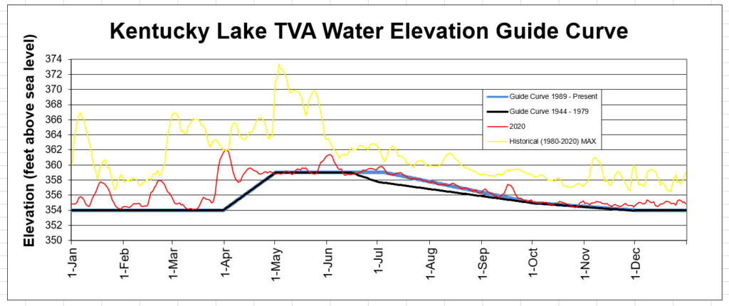
See the TVA Guide Curve Chart (black/blue line) below.
Winter Pool elevation is 354’ held between December 1 – April 1. Spring fill occurs during the month of April. Summer Pool elevation is 359’ and held between May 1 – July 5. Fall drawdown begins following July 4th holiday weekend to December.
History on Fall Drawdown
Prior to 1980’s, Kentucky Lake from its origin, fall drawdown began on June 15. (Why? See Question #4.) The Tourism industry petitioned TVA and Congressional leaders to extend summer pool through the July 4th weekend. Prior to the 1980’s, boaters during the July 4th holiday weekend would have contended with water levels around the 357’ elevation. (What does that mean? See Question #3.)
2. Does the water level fluctuate a lot from the Guide Curve?
Yes, it can and will. See Historical MAX level (yellow) on Guide Curve above. Higher water levels can be expected during rain events. It typically does not vary much lower than the Guide Curve. See data on Guide Curve for 2020 (above in red).
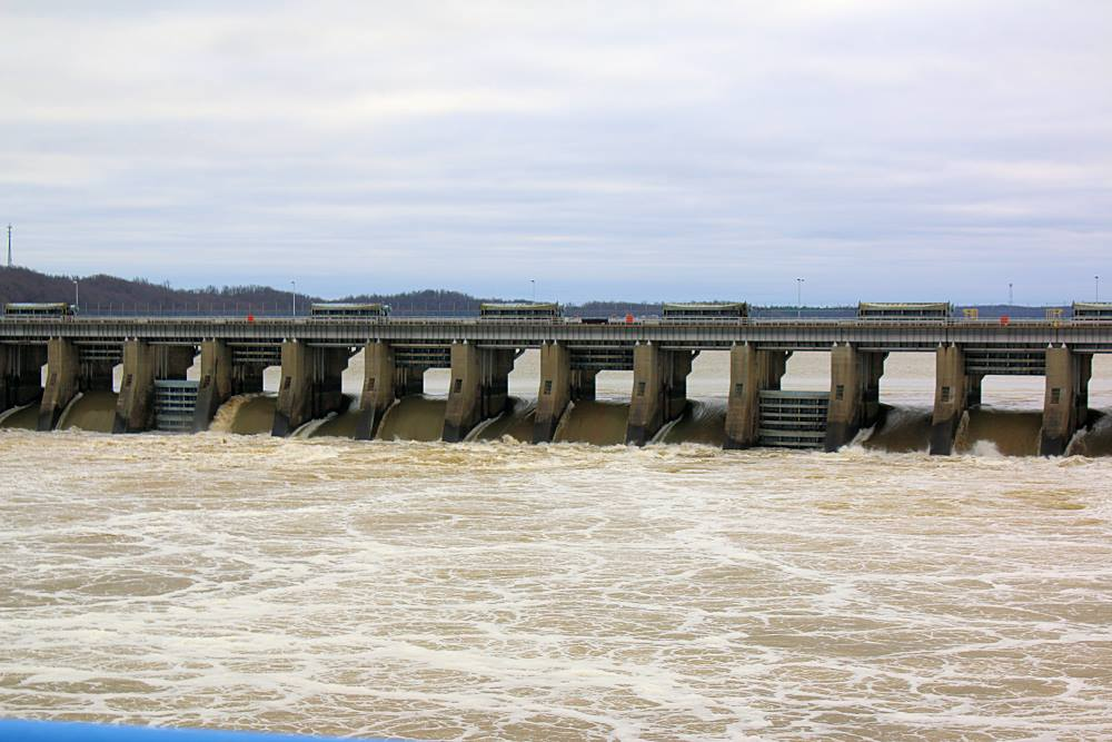
3. What do water levels mean while I am boating on Kentucky Lake?
4. Why does TVA raise and lower the water levels?
Outside of rain or drought events, the lake levels “by design” fluctuate five feet (winter – summer pool). The “by design” means TVA is maintaining water levels for flood control, navigation and hydropower under the lakes congressional charter.
5. Why can’t TVA keep summer pool level till after Labor Day weekend?
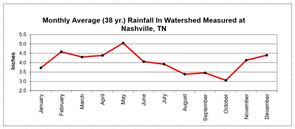
Back to navigation, hydropower and flood control, but mostly the first two. July-Sept. are typically the dryer seasons for the watershed. See the rainfall chart below. To keep the lower rivers navigable for barge traffic, water must be released from the lake (think of the lake as a storage facility). Also, because of warmer weather, people have their air conditioners running, which demands electricity, which for the region comes from hydropower. To a lesser degree, there is a need to get the water out of the “storage facility” as that space will be needed for fall and winter rain and snow melt. Then, there are some biological reasons for fish and wildlife.
6. Why does the lake level fluctuate so much when it rains?
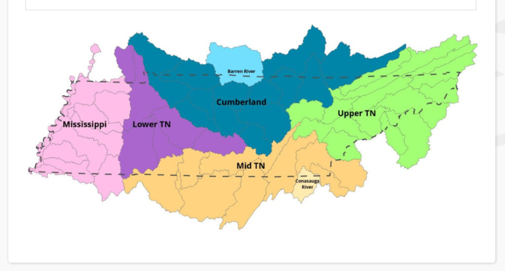
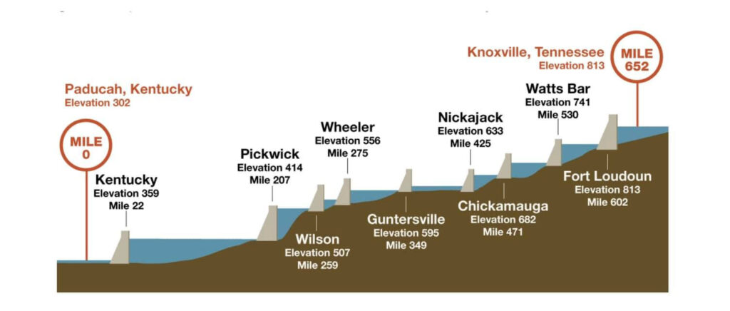
TVA has 49 dams on the Tennessee River used to tame the river. Nine of these dams are “mainstem.” Kentucky Lake is the last mainstem reservoirs on the Tennessee River. It is impacted by the full 40,890 sq. miles of watershed the Tennessee River encompasses. That is slightly bigger than the land mass of the whole state of Kentucky (40,409 sq. mi.), or almost the size of 27 Rhode Islands. Just the Kentucky Lake portion of the Tennessee River drainage is 1,460 sq. mi., just under the size of one Rhode Island (1,545 sq. mi.). The drainage of the Tennessee River comes from seven states. So, rain throughout the drainage, ends up at Kentucky Lake. Check out this graphic showing the river basins.
To be better prepared for water levels on Kentucky Lake, you can download the TVA Water Level app to your smartphone, or that information is available online.
Water data provided by KY F&W, TVA and MSU Biological Station.
Paul Rister